


The story began about 420 million years ago, at a time when Australia was still part of the ancient continent of Gondwana (see "The Changing Shape Of Gondwana" in Geological section on Diagrams page). The Australian land mass was very different then. The east coast was about 120-150km west of the present coastline, running roughly from Cape Melville to west of Charters Towers. A trip to present day Chillagoe, had we been around, would have entailed a boat ride because it was well under the sea - as were present day Cairns, Atherton and Townsville. The coastal section of the Wet Tropics is therefore a relatively recent addition to the ancient Australian continent.
As always in geological processes, a redistribution of land was taking place. Gradually, but persistently, rivers running off the continent were carrying bits of it into the sea in the form of gravel, sand and clay. This material was being deposited in an undersea basin, known as the Hodgkinson Basin, which lay off the coast possibly between it and another landmass even further to the east. About 160km wide, this basin stretched 320km from north to south, roughly from Cooktown to Tully. Over a period of about 60 million years, sediments accumulated in this basin, creating beds some 10km thick. Towards the edges, primitive corals and other marine organisms were creating mounds of limestone.
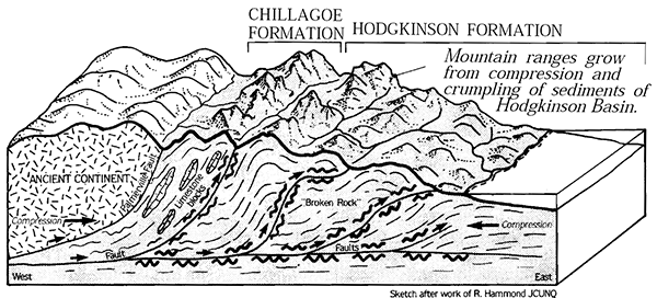
About 360 million years ago the sediments in the Hodgkinson Basin were caught in a squeeze. Major movements in the earth’s crust put them under immense pressure as opposing forces pushed in from east and west. The accumulated sediments were compressed, folded and lifted far above sea level, creating a series of mountain ranges that would rival today’s Andes or Himalayas in height. Coastal limestone accumulations were pushed up near to the old continent and can be seen today in the limestone formations of Chillagoe. Other sediments - sand, mud and gravel - formed the other mountain ranges, the immense pressure and heat transforming them, in the process, into tougher metamorphic rocks. These are the rocks which form much of the landscape we see in the Wet Tropics today.
From about 310 to 260 million years ago, other events deep in the Earth’s crust caused further changes in the landscape. It is difficult to imagine rocks acting like liquids, but from time to time large pools of molten rock (magma) pushed up into the crust from as far as 50km below the Earth’s surface. Less dense, and therefore more buoyant, than the rocks above them, this magma squeezed up through them. 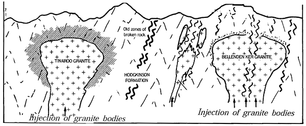 In many places this material did not make it to the surface, but slowly cooled and solidified to form bodies of granite deep underground. In the southern and western parts of the Wet Tropics area, some of that magma reached the surface, erupting explosively as volcanoes and spreading volcanic ash, dust and debris far and wide. This cooled rapidly to form hard rock known as tuff.
For over 100 million years, there were no dramatic geological changes in the Wet Tropics region. The mountains of the north-east coast continued to rise but were also subjected to the persistent processes of erosion. Rocks were broken down into sediments and carried by rivers to the sea. Gradually the granite, once deep below the surface, was exposed, as rocks covering it were removed. During this period Gondwana was breaking apart and Australia was drifting north. At that time the Australian continent extended much further east than it does now and included parts of New Zealand.
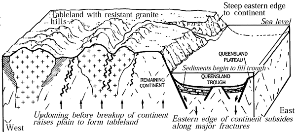
Then, about 100-65 million years ago, movements in the molten mantle, deep below the earth’s surface, stretched the continental crust above. It was pushed up and, like the crust of a cake rising in the oven, it eventually cracked under the strain and broke into blocks. Some of these blocks sank below sea level, one forming the floor to the Coral Sea Basin, and another the Queensland Trough, a deep trench at the edge of the continental shelf. One block, however, was raised well above sea level. The cliffs at its edge formed a sharp escarpment, at the shoreline, running the length of Australia’s east coast at the edge of what is now the continental shelf.
Nothing stands still for long in geological time. Falling over the escarpment, eroding rivers continued their gradual, persistent, reduction efforts. Little by little, as it was eaten away, the position of the escarpment shifted further and further west. Those sections with hard granite rocks withstood the erosion process better than others.
 As a result the escarpment lost its clear line and became a wandering edge to the upland Tablelands areas. Tougher rocks remained as isolated hills and islands such as the Whitfield Range and Walsh’s Pyramid near Cairns, Fitzroy, Hinchinbrook and Magnetic Islands, the Paluma range and Castle Rock in Townsville, to name but a few.
Sediments eroded from the higher mountains were (and still are) deposited on lower ground. At first, most would have been dumped over the cliff and straight into the sea, but as a coastal plain was created at the base of the mountains, sediments built up on this. The eastern section of this plain, now known as the continental shelf and partly occupied by the Great Barrier Reef, was often dry land. Sea levels have fluctuated dramatically over the last 2 million years, as much of the world’s water was captured by the polar ice caps during the various Ice Ages and then released in interglacial periods. The present sea level is one of the highest on record. The actual size of the coastal plain has varied as the shoreline has advanced and retreated according to sea levels.
The next chapter in the geological story of the Wet Tropics was a violent volcanic one which was felt particularly forcefully on the Atherton Tableland. From about 7 million years ago, vast amounts of lava flowed from a number of shield volcanoes, spreading over the landscape and cooling to form a dense layer of basalt. Later events were more explosive creating volcanic cones and craters which are a feature of the landscape today.
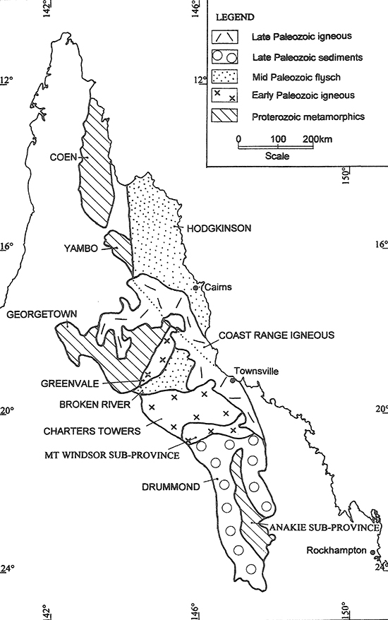 The greater Wangetti region lies on the coastal edge of the Hodgkinson Province (part of the larger Mossman Orogen - see "Queensland Geological Orogens And Provinces" in Geological section on Diagrams page) which consists of Siluro-Devonian flysch sediments, deformed and metamorphosed in the Devonian, and unconformably overlain by Devonian to Carboniferous shallow marine clastic and carbonate sediments. Not far from Cairns, to the immediate west of the lower Hodgkinson Province section, is the northern section of the Coastal Range Igneous Province. This area is constituted by Carboniferous to Permian felsic granitoids and erosional remnants of the coeval volcanic and subvolcanic complexes.
To elaborate, the Hodgkinson Province consists of Paleozoic turbiditic siliciclastics with subordinate limestone, chert, and mafic volcanics. These rocks are mostly unfossiliferous, except for the limestone and chert (see "North Queensland Geological Map" in Geological section on Diagrams page). The oldest rocks are Ordovician siliciclastic rocks that are located along the western margin of the province, adjacent to the Palmerville Fault. The oldest unit (Mulgrave Formation), which is interpreted as Early Ordovician in age, consists of quartz-rich sandstone that is interbedded with lesser mudstone, siltstone and shale, with local mafic volcanic rocks. This unit is structurally intercalated with the Mountain Creek Conglomerate, which consists of massive conglomerate with subordinate limestone and sandstone. The limestone is interpreted to have been deposited in very shallow water as indicated by the presence of ooids. Conodont data indicate that the limestone has a mid-Ashgillian age of 450-443 Ma. The Van Dyke Litharenite is intercalated with the Mulgrave Formation in two discontinuous, north-trending belts that can be traced for 20 km. Although no age control exists for these rocks, they have been assigned an Ordovician age based upon a grain population similar to the Mulgrave Formation. Silurian-Devonian rocks in the Hodgkinson Province include two units, the Chillagoe Formation (mainly limestone, chert, mafic volcanic rocks and sandstone), which is exposed in the west of the province, forming a linear belt adjacent or close to the Palmerville Fault, and the Hodgkinson Formation (mainly sandstone, siltstone and mudstone, with subordinate chert, mafic volcanic rocks and conglomerate), which makes up most of the province. Mafic volcanic rocks in the Hodgkinson Formation, which include basalt, basaltic andesite and andesite/dacite, were initially considered to have a MORB-like geochemical signature, but additional data indicate a possible relationship to subduction. The ages of the Chillagoe and Hodgkinson Formations rocks are poorly constrained, with the best constraints on the Chillagoe Formation, where conodonts indicate a Telychian-Emsian age (407-399 Ma). Faunal assemblages indicate ages from Early to Late Devonian, with Leptophloeum australe fossils in the western and central parts of the exposed Hodgkinson Formation indicative of a Late Devonian-Mississippian age. The youngest detrital zircon population from six Hodgkinson Formation samples was 360 +/- 6 (n = 5), which is consistent with the fossil data. It is also consistent with an age constraint imposed by the 357 +/- 6 Ma Mount Formartine Supersuite, which intrudes the Hodgkinson Formation. These rocks are also intruded by the 347 +/- 6 Ma Emerald Creek Microgranite, which is partially stoped out by the Permian Tinaroo Granite (Kennedy Igneous Association). The Hodgkinson Province is overlain by restricted Carboniferous to Triassic non-marine successions including conglomerate, coal measures, volcanic rocks and sandstone including rocks of the Ngarrabullgan and Lakefield basins. Regional metamorphism is sub-greenschist facies, except for higher-grade aureoles around (and above or below) now eroded inferred granites. The Hodgkinson Province has been folded and faulted by several deformation events. The tectonic origin of the Hodgkinson Province is controversial, with some workers advocating an accretionary prism or subduction complex, whereas others advocating an extensional environment. The Hodgkinson Province contains a number of small deposits, including Besshi-type volcanic-hosted massive sulphide deposits (e.g., Mount Molloy, Dianne, OK), Carboniferous to Permian lode gold deposits of the Hodgkinson gold field, and a number of granite-related, particularly tin, tungsten and gold, deposits (e.g. Mount Garnet, Collingwood, Mungana and Red Dome).
(see "Structure Of The Earth" in Geological section on Diagrams page)
Accretion - is a process by which material is added to a tectonic plate at a subduction zone, frequently on the edge of existing continental landmasses. The added material may be sediment, volcanic arcs, seamounts, oceanic crust or other igneous features
Andesite - is a volcanic rock of intermediate composition. In a general sense, it is the intermediate type between silica-poor basalt and silica-rich rhyolite. It is fine-grained (aphanitic) to porphyritic in texture, and is composed predominantly of sodium-rich plagioclase plus pyroxene or hornblende
Athenosphere - is the mechanically weak and ductile region of the upper mantle of Earth. It lies below the lithosphere, at a depth between 80 and 200 km below the surface, and extends as deep as 700 km. However, the lower boundary of the asthenosphere is not well defined
Aureole - a region in which country rocks surrounding an intrusion have been recrystallized in response to the heat supplied by the intrusion
Basalt - is a fine-grained extrusive igneous rock formed from the rapid cooling of low-iscosity lava rich in magnesium and iron (mafic lava) exposed at or very near the surface of the Earth
Basin - a depression, or dip, in the Earth's surface
Cementation - involves ions carried in groundwater chemically precipitating to form new crystalline material between sedimentary grains
Chert - is a hard, fine-grained sedimentary rock composed of microcrystalline or cryptocrystalline quartz
Clastic - composed of fragments, or clasts, of pre-existing minerals and rock
Coeval - having the same age or date of origin
Conglomerate - is a clastic sedimentary rock that is composed of a substantial fraction of rounded to subangular gravel-size clasts. A conglomerate typically contains a matrix of finer-grained sediments, such as sand, silt, or clay, which fills the interstices between the clasts. The clasts and matrix are typically cemented by calcium carbonate, iron oxide, silica, or hardened clay
Conodonts - an extinct group of agnathan (jawless) vertebrates resembling eels, classified in the class Conodonta. Conodont elements are widely used as index fossils, fossils used to define and identify geological periods
Continental Shelf - is the submerged area which forms the edge of a continent, ending in a steep slope to the depths of the ocean
Crust - is a thin shell on the outside of Earth, accounting for less than 1% of Earth's volume. It is the top component of the lithosphere, a division of Earth's layers that includes the crust and the upper part of the mantle
Dacite - is a volcanic rock formed by rapid solidification of lava that is high in silica and low in alkali metal oxides. It has a fine-grained (aphanitic) to porphyritic texture and is intermediate in composition between andesite and rhyolite. It is composed predominantly of plagioclase feldspar and quartz
Erosion - is the action of surface processes (such as water flow or wind) that removes soil, rock, or dissolved material from one location on the Earth's crust and then deposits it to another location
Escarpment - is a steep slope or long cliff that forms as a result of faulting or erosion and separates two relatively level areas having different elevations
Extensional Tectonics - is concerned with the structures formed by, and the tectonic processes associated with, the stretching of the Earth's crust or lithosphere
Extrusion - refers to magma reaching the surface of the Earth through a volcano or volcanic vent
Facies - encompasses all of the characteristics of a rock including its chemical, physical, and biological features that distinguish it from adjacent rock
Fault - is a planar fracture or discontinuity in a volume of rock across which there has been significant displacement as a result of rock-mass movements
Fossiliferous - containing fossils or organic remains
Flysch - is a sequence of sedimentary rock layers that progress from deep-water and turbidity flow deposits to shallow-water shales and sandstones
Geologic Orogen - develops as a compressed crust plate crumples and is uplifted to form one or more mountain ranges
Geologic Province - is a spatial entity with common geologic attributes
Granite - is a coarse-grained intrusive igneous rock composed mostly of quartz, alkali feldspar, and plagioclase. It forms from magma that slowly cools and solidifies underground
Igneous Rock - is formed through the cooling and solidification of magma or lava
Interbedding - occurs when beds (layers of rock) of a particular lithology lie between or alternate with beds of a different lithology
Intercalation - a special form of interbedding, where two distinct depositional environments in close spatial proximity migrate back and forth across the border zone
Intrusion - the movement of magma through underground rocks within the Earth, usually in an upward direction
Lava - is molten or partially molten rock that has been expelled from the interior of the Earth onto its surface
Limestone -is a type of carbonate sedimentary rock composed mostly of the minerals calcite and aragonite, which are different crystal forms of CaCO
Litharenite - sandstone with a significant (greater than 5%) component of lithic fragments, though quartz and feldspar are usually present as well, along with some clayey matrix
Lithics - are pieces of other rocks that have been eroded down to sand size and now are sand grains in a sedimentary rock
Lithology - of a rock unit is a description of its physical characteristics visible at outcrop, in hand or core samples, or with low magnification microscopy
Lithosphere - is the rigid, outermost rocky shell of the Earth. It is composed of the crust and the portion of the upper mantle that behaves elastically on time scales of up to thousands of years or more. The lithosphere is broken into tectonic plates that move, allowing heat to escape from the interior of Earth into space
Mafic Rock - is a silicate mineral or igneous rock rich in magnesium and iron
Magma - is the molten or semi-molten natural material, found beneath the surface of the Earth, from which all igneous rocks are formed
Mantle - is a layer of silicate rock between the crust and the outer core. Its mass of 4.01 × 1024 kg is 67% the mass of the Earth. It has a thickness of 2,900 kilometres making up about 84% of Earth's volume. It is predominantly solid, but in geological time it behaves as a viscous fluid
Metamorphic Rock - arises from the transformation of existing rock to new types of rock in a process involving intense heat and pressure
MOR - (Mid Ocean Ridge) is a seafloor mountain system formed by plate tectonics. It typically has a depth of about 2,600 meters and rises about 2,000 meters above the deepest portion of an ocean basin
MORB - (Mid Ocean Ridge Basalt) is a type of tholeiitic basalt, erupted from mid-ocean-ridge constructive-plate margins; it is one of the most abundant of all rocks and covers much of the Earth's surface. It is characterized by very low concentrations of K2O and TiO2; low iron, P2O5, Ba, Rb, Sr, Pb, Th, U, and Zr; and high CaO
Mudstone - is a fine-grained sedimentary rock whose original constituents were clays or muds
Ooids - are small (commonly less than 2 mm in diameter), spheroidal, coated (layered) sedimentary grains, usually composed of calcium carbonate, but sometimes made up of iron- or phosphate-based minerals
Quartz - is a hard, crystalline mineral composed of silica (silicon dioxide)
Sandstone - is a clastic sedimentary rock composed mainly of sand-sized (0.0625 to 2 mm) silicate grains. Sandstones comprise about 20–25% of all sedimentary rocks
Sediment - a naturally occurring material that is broken down by processes of weathering and erosion, and is subsequently transported by the action of wind, water, or ice or by the force of gravity acting on the particles
Sedimentary Rock - is formed by the accumulation or deposition of mineral or organic particles on the Earth's surface, followed by cementation
Shale - is a fine-grained, clastic sedimentary rock formed from mud that is a mix of flakes of clay minerals (hydrous aluminium phyllosilicates, e.g. kaolin, Al2Si2O5(OH)4) and tiny fragments (silt-sized particles) of other minerals, especially quartz and calcite
Shield Volcano - is a type of volcano named for its low profile, resembling a warrior's shield lying on the ground. It is formed by the eruption of highly fluid (low viscosity) lava
Siliciclastic Rock - is clastic non-carbonate sedimentary rock that is composed primarily of silicate minerals, such as quartz or clay minerals
Siltstone - also known as aleurolite, is a clastic sedimentary rock that is composed mostly of silt
Stope - a hollow left by underground rock or earth movement
Subduction - is a geological process in which the oceanic lithosphere is recycled into the Earth's mantle at convergent boundaries
Supersuite - is a grouping of suites that show similar characteristics but which also show distinct differences between the component suites. It is the analogue of a lithostratigraphic supergroup
Tectonic - relating to the processes that control the structure and properties of the Earth's crust and its evolution through time. These include the processes of mountain building, the growth and behavior of the strong, old cores of continents known as cratons, and the ways in which the relatively rigid plates that constitute the Earth's outer shell interact with each other
Tholeiitic - is one of two main magma series in subalkaline igneous rocks, the other being the calc-alkaline series. Tholeiitic rock types tend to be more enriched in iron and less enriched in aluminium than calc-alkaline rock types. They are thought to form in a less oxidized environment than calc-alkaline rocks
Trough - is a linear structural depression that extends laterally over a distance
Tuff Rock - is made of volcanic ash ejected from a vent during a volcanic eruption
Turbidite - is the geologic deposit of a turbidity current, which is a type of amalgamation of fluidal and sediment gravity flow responsible for distributing vast amounts of clastic sediment into the deep ocean