

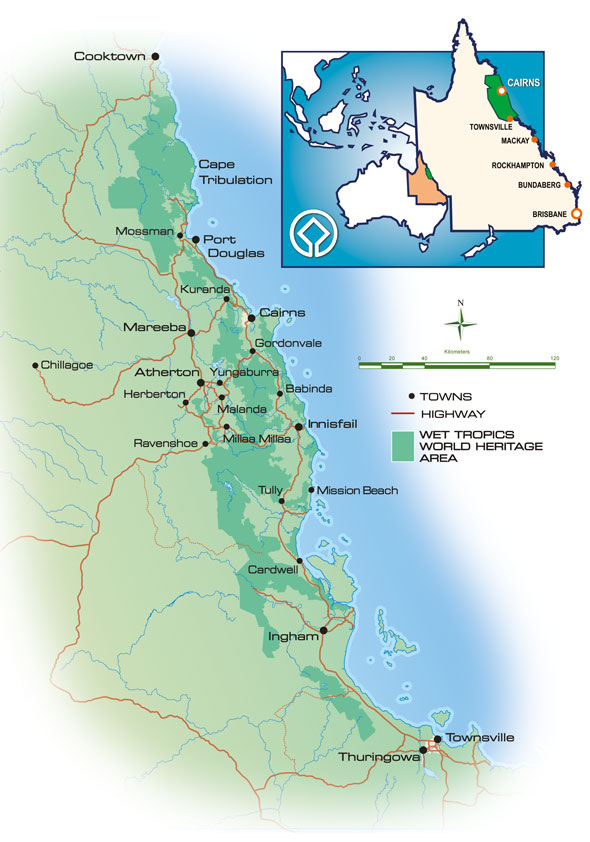
The Wet Tropics Management Authority is charged with managing the Wet Tropics World Heritage Area, according to Australia's obligations under the World Heritage Convention.
In 1990 the Commonwealth and Queensland governments agreed on a framework to manage the Wet Tropics World Heritage Area. They decided to establish a small agency based in Cairns which would be responsible for managing the Area. The Authority was officially established under the Wet Tropics World Heritage Protection and Management Act 1993.
Under the primary goal of the World Heritage Convention, the Authority must provide for the implementation of Australia's international duty to protect, conserve, present, rehabilitate and transmit the Wet Tropics of Queensland World Heritage Area to future generations.
The Authority is responsible to both the Australian and Queensland governments through the Wet Tropics Ministerial Council and has an independent Board of Directors appointed by both governments. Administratively the Authority is a division within the Queensland Government's Department of Environment, Science and Innovation.
The Authority administers the Queensland Government's Wet Tropics legislation and sets policies and procedures which govern activities and land use within the Wet Tropics of Queensland World Heritage Area.
As of 2017 the Authority employs about 52 staff and works in partnership to manage the Area with a range of government agencies, land managers and landholders, rainforest aboriginal people, research organisations, local governments, tourism and community groups. The Board has appointed a range of committees and liaison groups to provide it with advice on community issues, scientific matters and sectoral interests. The Authority has a Strategic Plan 2020 - 2030 to guide its operations.
The Authority is responsible for policy and the coordination of on-the-ground management to ensure the World Heritage Area is properly protected. The Queensland Parks and Wildlife Service and other land managers are responsible for day-to-day management issues such as maintenance, routine permits, and enforcement activities.
The Authority's main functions are to:
- develop and implement management plans, policies and programs
- administer funding arrangements
- promote, research, and monitor the state of the Wet Tropics
- enter into cooperative management agreements and other arrangements with land holders and aboriginal people
- develop community education programs
- promote the Wet Tropics locally, nationally, and internationally
The Queensland Parks and Wildlife Service (QPWS) is a business division of the Department of Environment, Science and Innovation within the Government of Queensland. The division’s primary concern is with the management and maintenance of protected areas within Queensland, to protect and manage Queensland’s parks, forests and the Great Barrier Reef for current and future generations.
The QPWS managed areas include more than 1000 national parks, state forests, marine parks and other protected areas, and five world heritage areas. Of these, 220 are national parks.![]() Queensland’s first national park, Witches Falls (in today’s Tamborine National Park), was established on 28 March 1908, followed by Bunya Mountains National Park in July 1908, and then Lamington National Park in 1915. From modest early beginnings within the Forestry department, a dedicated national parks service was established in 1975—the Queensland Parks and Wildlife Service. From that time, park rangers have proudly worn QPWS uniform badge featuring the symbol, Herbie (Herbert River ringtail possum), which has become one of the most well-recognised symbols in Queensland.
Queensland’s first national park, Witches Falls (in today’s Tamborine National Park), was established on 28 March 1908, followed by Bunya Mountains National Park in July 1908, and then Lamington National Park in 1915. From modest early beginnings within the Forestry department, a dedicated national parks service was established in 1975—the Queensland Parks and Wildlife Service. From that time, park rangers have proudly worn QPWS uniform badge featuring the symbol, Herbie (Herbert River ringtail possum), which has become one of the most well-recognised symbols in Queensland.
The Nature Conservation Act 1992, Marine Parks Act 2004 and Forestry Act 1959 provide guiding legislation for the service.
Protected areas in Queensland are needed to provide wildlife habitat to maintain biodiversity and provide opportunities for outdoor nature-based activities. Managing national parks involves protecting a park's natural condition and processes, presenting the park's cultural and natural resources and its values; and ensuring that park use is nature-based and ecologically sustainable.
Managing multiple-use marine parks involves providing refuge areas for species and ecosystems while allowing for continuing recreational and commercial use of the majority of the marine environment.
A Master Plan for Queensland's Park System outlines the directions for management of all protected areas in Queensland for the next 20 years.
QPWS is responsible for day-to-day management of Queensland’s five World Heritage areas, which are (mostly) within the protected area estate. These properties are outstanding examples of the world's natural or cultural heritage, and provide highly valuable environmental, tourism and economic services for Queensland.
For each park, either a management statement or a management plan is prepared to identify the park's special values and determine ways to ensure those values are preserved, enhanced or maintained.
The service employs park rangers who are responsible for constructing and maintaining infrastructure such as camping areas, picnic areas, amenities, walking tracks and lookouts providing advice to visitors, recording wildlife data, controlling feral plants and animals, assisting in the preparation of management plans and enforcing park rules.
QPWS also works closely with Aboriginal Traditional Owners and, in some places, volunteers, as well as other government departments and organisations to conserve, manage, share and present Queensland’s most precious natural and cultural places.
In addition to its ranger capability, the QPWS also provides a firefighting service, QPWS Fire Management, that operates within National Parks, State Parks and Conservation parks, among others. QPWS Fire Management conducts both hazard reduction burns alongside responding to other fires within its area.
The Great Barrier Reef Marine Park protects a large part of Australia's Great Barrier Reef from damaging activities. It is a vast multiple-use Marine Park which supports a wide range of uses, including commercial marine tourism, fishing, ports and shipping, recreation, scientific research and Indigenous traditional use. Fishing and the removal of artefacts or wildlife (fish, coral, seashells, etc.) is strictly regulated, and commercial shipping traffic must stick to certain specific defined shipping routes that avoid the most sensitive areas of the park. The Great Barrier Reef is the largest and best known coral reef ecosystem in the world. Its reefs, almost 3000 in total, represent about 10 per cent of all the coral reef areas in the world. It supports an amazing variety of biodiversity, providing a home to thousands of coral and other invertebrate species, bony fish, sharks, rays, marine mammals, marine turtles, sea snakes, as well as algae and other marine plants.
Managing Authority
The Great Barrier Reef Marine Park Authority (GBRMPA) is responsible for the care and protection of the Great Barrier Reef Marine Park. It uses a range of tools to manage the marine park including Acts and Regulations, zoning plan, plans of management, traditional owner agreements, partnerships, stewardship and best practice, education, research and monitoring and reporting. It issues permits for various forms of use of the marine park, and monitors usage in the park to ensure compliance with rules and regulations associated with the park. GBRMPA is funded by Commonwealth Government appropriations and an environmental management charge levied on the permit-holders' passengers. Currently this is A$6.00 per day per passenger (to a maximum of $16.50 per trip).
In May 2022 the Darumbal people were officially recognised as the traditional custodians of an expanse of ocean covering 36,606 km2 (14,134 sq mi) off the Central Queensland Coast, making it the largest Traditional Use of Marine Resources Agreement (TUMRA) on the reef. The agreement created a partnership with GBRMPA and Queensland's Department of Environment and Science. The occasion was marked by a ceremony on the beach at Emu Park.
Description
The marine park lies east of the mainland coast of Queensland, starting in the north at Cape York. Its northern boundary is the circle of latitude 10°41'S (running east up to the eastern edge of the Great Barrier Reef at 145º19'33"E), thereby encompassing those few uninhabited Torres Strait Islands that are east of Cape York, south of 10°41'S and north of 11°00'S. The largest of those island are Albany Island (5.9 km2 or 2.3 sq mi), Turtle Head Island 12.8 km2 or 4.9 sq mi and Trochus Island 2.2 km2 or 0.85 sq mi. Further islands are Mai Island 0.25 km2 or 0.097 sq mi, Bush Island 0.2 km2 or 0.077 sq mi, Tree Islet 0.01 km2 or 0.0039 sq mi, Brewis Island 0.05 km2 or 0.019 sq mi, and a few unnamed islets.
Its southern boundary lies south of Gladstone and north of Bundaberg, taking in Lady Elliot Island.
Protected Area Designation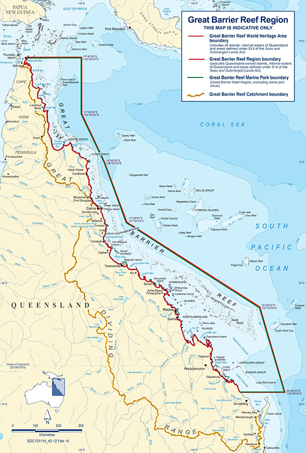 As of 2016, zones within the marine park has been categorized into the following IUCN protected area categories:
- IUCN Category Ia with an area of 859 square kilometres (332 sq mi) being about 0.2% of the marine park's area,
- IUCN Category II with an area of 114,309 square kilometres (44,135 sq mi) being about 33%,
- IUCN Category IV with an area of 15,027 square kilometres (5,802 sq mi) being about 4%
- IUCN Category VI with an area of 213,769 square kilometres (82,537 sq mi) being about 62%.
History
In 1975, the Government of Australia enacted the Great Barrier Reef Marine Park Act 1975, which created the Great Barrier Reef Marine Park Authority, and defined what acts were prohibited on the Reef. Joe Baker, who was involved in the bid to make the Great Barrier Reef World Heritage-listed in 1981, was a founding member of the Great Barrier Reef Marine Park Authority.
The Australian Government has also recognised the ecological significance of this Park by its inclusion in the Nation's Biodiversity Action Plan. The Government of Australia manages the reef through the Great Barrier Reef Marine Park Authority and in partnership with the Government of Queensland, to ensure that it is widely understood and used in a sustainable manner. A combination of zoning, management plans, permits, education and incentives (such as eco-tourism certification) is used in an effort to conserve the Great Barrier Reef.
As many species of the Great Barrier Reef are migratory, many international, national, and interstate conventions or pieces of legislation must be taken into account when strategies for conservation are made.
Some international conventions that the Great Barrier Reef Marine Park must follow are: the Bonn Convention, Ramsar Site (for the Bowling Green Bay National Park site), CITES, JAMBA and CAMBA. Some national legislation that the Park must follow are: Great Barrier Reef Marine Park Act 1975, Environment Protection and Biodiversity Conservation Act 1999, National Strategy for Ecologically Sustainable Development, National Strategy for the Conservation of Australia's Biological Diversity, Australia's Oceans Policy, National Strategy for the Conservation of Australian Species and Communities Threatened with Extinction. Some state legislation that the Park must follow are: Nature Conservation Act 1992, Marine Parks Act 1982, Fisheries Act 1994, Queensland Nature Conservation (Wildlife) Regulation 1994.
For example, the Queensland Government has enacted several plans attempting to regulate fishing. The East Coast Trawl Management Plan 1999 aimed to regulate trawling by limiting the times when trawling is permitted and restricting the gear used. The Fisheries (Coral Reef Fin Fish Fishery) Management Plan 2003 aimed at reducing the annual commercial catch to 1996 levels, disallowing fishing when the fish are spawning and increasing the minimum legal size of fish.
The Great Barrier Reef was selected as a World Heritage Site in 1981. Up until 1999, there were four main zones in the Great Barrier Reef Marine Park. They were the "Far Northern", "Cairns", "Central" and "Mackay/Capricorn" sections. These zoning sections were created between 1983 and 1987. Another section, the "Gumoo Woojabuddee" section was declared in 1998. Each section had its own zoning plan. The Great Barrier Marine Park Zoning Plan 2003 superseded all previous zoning plans, coming into effect on 1 July 2004.
In July 2004, a new zoning plan was brought into effect for the entire Marine Park, and has been widely acclaimed as a new global benchmark for the conservation of marine ecosystems. The rezoning was based on the application of systematic conservation planning techniques, using the MARXAN software. On 1 July 2004 the Great Barrier Reef Marine Park became the largest protected sea area in the world when the Australian Government increased the areas protected from extractive activities (such as fishing) from 4.6% to 33.3% of the park. As of 2006, the Northwestern Hawaiian Islands National Monument is the largest protected marine area in the world. The management committee draws inspiration from the Great Barrier Reef Marine Park Authority's management strategies.
The current method of zoning is called the "Representative Areas Program", which chooses "typical" areas of the Great Barrier Reef Marine Park. They can then be protected in "Green Zones" (no-take zones). The Great Barrier Reef World Heritage Area has been divided into 70 bioregions, of which 30 are reef bioregions, and 40 are non-reef bioregions.
In 2006, a review was undertaken of the Great Barrier Reef Marine Park Act 1975. Some recommendations of the review are that there should be no further zoning plan changes until 2013, and that every five years, a peer-reviewed Outlook Report should be published, examining the health of the Great Barrier Reef, the management of the Reef, and environmental pressures.
Threats
The most significant threats to the GBR are:
- Climate change, leading to increased sea temperatures and consequently, coral bleaching events
- Crown-Of-Thorns Starfish
- Industrial and agricultural run-off
Outlook For The Reef
The Great Barrier Reef Outlook Report 2014, published every five years, examines the Great Barrier Reef's health, pressures, and likely future.
The report is required under Great Barrier Reef Marine Park Act 1975 (section 54) and aims to provide a regular and reliable means of assessing reef health and management in an accountable and transparent way.
The report finds the greatest risks to the Reef are still climate change, land-based run-off, COT Starfish, coastal development, some fishing impacts, illegal fishing and poaching.
Associated Protected Areas
The Great Barrier Reef Coast Marine Park is a marine protected area located in Queensland waters adjoining the Great Barrier Reef. It was created on 5 November 2004 by the amalgamation of the following former marine parks – the Mackay/Capricorn Marine Park, the Townville/Whitsunday Marine Park, the Trinity Inlet/ Marlin Coast Marine Park and the Cairns Marine Park, along with the addition of previously unprotected area of coastal water that adjoined the former marine parks listed above. The marine park is intended to complement the adjoining GBRMP by the use of "similar zone objectives, and entry and use provisions". It is managed by the Queensland Parks and Wildlife Service.
The Department of Environment, Tourism, Science and Innovation is a department of the Queensland Government which is responsible for protecting the state's natural environment, developing the government's science strategy, and driving the government's policy and program direction for young people in Queensland. The department provides administrative support for the Queensland Heritage Council and the Queensland Heritage Register.
The Department of Environment and Heritage Protection was established in April 2012, as part of a series of changes to the machinery of government after the LNP's win at the 2012 election. The department took on most of the functions of the Department of Environment and Resource Management which was dissolved. In December 2017, it was renamed to the Department of Environment and Science. In December 2023, it was renamed to the Department of Environment, Science and Innovation. In November 2024, it was renamed to the Department of the Environment, Tourism, Science and Innovation.
DETSI recognises the enormous value a clean environment, innovative society and economy, and vibrant culture contributes to our lives.
As a diverse organisation, the department brings together key areas of work to achieve those objectives for a better Queensland.
By being effective leaders and partners in managing, protecting and restoring Queensland’s natural environment and heritage, the department helps ensure the health and prosperity of current and future generations.
 DETSI Responsibilities -
Environment
- protect and manage our parks, forests and the Great Barrier Reef for current and future generations
- enhance Queensland’s ecosystems
- conserve and protect Queensland’s biodiversity and threatened species
- protect significant heritage places
- implement improved waste management and resource recovery
- develop and deliver programs supporting climate action
- avoid, minimise or mitigate impacts to the environment
Tourism
- only recently brought under the care of the DETSI, tourism is vital to Queensland’s economy, for creating jobs, attracting investment and sustaining communities.
- by working together, we can strengthen Queensland’s position as a world-leading tourism destination and meet the changing demands of our domestic and international visitors
Science
- lead the development of science strategy for government
- deliver scientific expertise to protect and manage our environment and natural resource base
- support the development of Queensland’s science sector
Innovation
- build our innovation economy to drive economic growth and create jobs in our regions
- support the development of the state’s innovation driven enterprises and innovation ecosystem
- promote the importance and contribution of entrepreneurship and investment in Queensland
- work with government, industry and the community to grow and develop our innovation precincts and places
The Department of Agriculture and Fisheries is a department of the Queensland Government which aims to maximise the economic potential for Queensland's primary industries on a sustainable basis through strategic industrial development. The section known as Biosecurity Queensland is responsible for biosecurity matters within the state.
Agriculture, Fisheries and Forestry provides expertise and support that increases primary industries productivity, expands markets and assists with adaption to change. It conducts research, policy advice, protects against pests and diseases, maintains animal welfare standards, as well as managing fisheries.
Across DAF's business groups, they are dedicated to ensuring the production and protection of Queensland’s rich natural resources. This work is of critical importance to DAF, Australia and the planet. Operating within diverse environments and industries, each of the business groups plays a vital role in this mission.
DAF's work makes a significant contribution to the Queensland Government’s objectives for the community through their strategies and service delivery initiatives.
They have more than 2,000 staff across 170 sites, making a tangible difference to the life and land of Queenslanders.
DAF's organisational chart reflects the high-level structure of the department and their visual identity represents their connection to the land, sea and each other. The business groups -
Agriculture
Agriculture enables industry businesses and government to improve market supply chains, manage risks, build resilience, and manage the delivery of regional assistance to industry. DAF undertakes research, development and extension that enriches Queensland’s agricultural businesses.
Biosecurity
Biosecurity Queensland leads the government’s efforts to prevent, respond to and recover from pests and diseases threating agricultural prosperity, the environment, social amenity and human health. We achieve this by maintaining access to markets, protecting animal welfare and reducing the risk of contamination from agricultural management.
Corporate
Corporate supports all business groups by delivering finance, information technology, communications and engagement services, digital engagement and systems management, human resources and organisational performance management.
Fisheries and Forestry
Fisheries and Forestry manages the sustainability and allocation of fisheries and forestry resources for all Queenslanders. It also incorporates the enforcement of fisheries and boating safety laws through the Queensland Boating and Fisheries Patrol. This enables profitable businesses and enjoyable recreational fishing experiences for locals and visitors.
There are 3 local councils operating in the Greater Wangetti Region -
Douglas Shire Council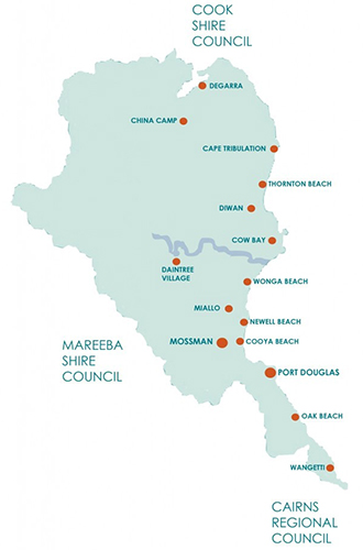 The Shire of Douglas is a local government area in Far North Queensland. It is located on the coast north of the city of Cairns. The shire, administered from the town of Mossman, covers an area of 2,428 square kilometres and existed as a local government entity from 1880 until 2008, when it was amalgamated with the City of Cairns to become the Cairns Region. Following a poll in 2013, the Shire of Douglas was re-established on 1 January 2014.
The major industries are tourism and sugar production. Minor industries include tropical fruit, beef and fishing.
In the 2021 census, the Shire of Douglas had a population of 12,337 people.
History
The Kuku Yalanji first nations people are the traditional inhabitants of the Mossman and Daintree areas of North Queensland. Their language region includes areas within the local government area of Shire of Douglas and Shire of Cook, particularly the localities of Mossman, Daintree, Bloomfield River, China Camp, Maytown, Palmer, Cape Tribulation and Wujal Wujal.
The traditional language region is Mossman River in the south to the Annan River in the north, bordered by the Pacific Ocean in the east and extending inland to west of Mount Mulgrave. It includes the head of the Palmer River, the Bloomfield River, China Camp, Maytown, and Palmerville.
On 11 November 1879, the Cairns Division was one of the initial 74 divisions created under the Divisional Boards Act 1879. On 3 June 1880, the northern part of Cairns Division was excised to create Douglas Division.
With the passage of the Local Authorities Act 1902, Douglas Division became the Shire of Douglas on 31 March 1903.
On 15 March 2008, under the Local Government (Reform Implementation) Act 2007 passed by the Parliament of Queensland on 10 August 2007, the Shire of Douglas merged with the City of Cairns to form the Cairns Region.
In 2012, a proposal was made to de-amalgamate the Shire of Douglas from the Cairns Region. On 6 December 2012, the Queensland Minister for Local Government, the Hon. David Crisafulli, granted the people of the former Douglas Shire a vote on possible de-amalgamation from the Cairns Regional Council, even though the Queensland Treasury Corporation had calculated the costs to be too high a burden on the few ratepayers of this small Shire, and the Shire to be unviable in the long term. Despite strong opposition from many parties, on 9 March 2013 the citizens of the former Douglas Shire voted in a referendum to de-amalgamate. The shire was re-established on 1 January 2014.
Cairns Regional Council
The Cairns Region is a local government area in Far North Queensland, Queensland, Australia, centred on the regional city of Cairns. It was established in 2008 by the amalgamation of the City of Cairns and the Shires of Douglas and Mulgrave. However, following public protest and a referendum in 2013, on 1 January 2014, the Shire of Douglas was de-amalgamated from the Cairns Region and re-established as a separate local government authority.
The Cairns Regional Council's 2023-24 operating budget is A$433.5 million. In the 2021 census, the Cairns Region had a population of 166,943 people.
History
The Yidinji first nations people are the traditional inhabitants of this country. Their traditional language region is within the local government areas of Cairns Region and Tablelands Region, in such localities as Cairns City (CBD), Gordonvale, and the Mulgrave River, and the southern part of the Atherton Tableland including Atherton and Kairi.
The Djabugay first nations people (including the Yirrganydji people) are the traditional inhabitants of the area north of the Barron River in the Cairns Region, with the traditional group extending west towards Mareeba and north towards Douglas Shire and Port Douglas.
Post colonialisation
Prior to the 2008 amalgamation, the Cairns Region consisted of the entire area of three previous local government areas:
- the City of Cairns
- the Shire of Douglas
- the Shire of Mulgrave.
The city, which for most of its existence covered only the central business district and inner suburbs of Cairns, had its beginning in the Borough of Cairns which was proclaimed on 28 May 1885 under the Local Government Act 1878. With the passage of the Local Authorities Act 1902, it became a Town on 31 March 1903 and was proclaimed a City on 12 October 1923.
The Shire of Mulgrave had its origins in the Cairns Division, one of Queensland's 74 divisions created under the Divisional Boards Act 1879 on 11 November 1879. The Douglas Division was created on 3 June 1880. They became the Shire of Cairns and the Shire of Douglas on 31 March 1903. On 20 December 1919, it grew to include some territory from the abolished Shire of Barron, and on 16 November 1940, the shire was renamed Mulgrave.
On 21 November 1991, the Electoral and Administrative Review Commission, created two years earlier, produced its second report, and recommended that local government boundaries in the Cairns area be rationalised, and that the Shire be dissolved and amalgamated with the City of Cairns. The Local Government (Cairns, Douglas, Mareeba and Mulgrave) Regulation 1994 was gazetted on 16 December 1994. On 22 March 1995, the Shire was abolished and became part of the new City of Cairns.
In July 2007, the Local Government Reform Commission released its report and recommended that Cairns amalgamate with the Shire of Douglas, and that the new Cairns Regional Council be undivided with 10 councillors and a mayor. On 15 March 2008, the City and Shire formally ceased to exist, and elections were held on the same day to elect councillors and a mayor to the Regional Council.
In 2012, a proposal was made to de-amalgamate the Shire of Douglas from the Cairns Region. On 9 March 2013, the citizens of the former Douglas shire voted in a referendum to de-amalgamate. The Douglas shire was re-established on 1 January 2014.
Mareeba Shire Council
The Shire of Mareeba is a local government area at the base of Cape York Peninsula in Far North Queensland, inland from Cairns. The shire, administered from the town of Mareeba, covered an area of 53,491 square kilometres, and existed as a local government entity from 1879 until 2008, when it amalgamated with several councils in the Atherton Tableland area to become the Tablelands Region.
On 20 March 2013, Mareeba residents voted in favour of a proposal to reverse the amalgamation and to re-establish Mareeba Shire. The new Mareeba Shire was re-established on 1 January 2014.
In the 2021 census, the Shire of Mareeba had a population of 22,858 people.
History
The Woothakata Division, based in the mining town of Thornborough on the Hodgkinson goldfield, was created on 11 November 1879 as one of 74 divisions around Queensland under the Divisional Boards Act 1879 with a population of 1836. Woothakata is a Wakaman and Kuku Djungan aboriginal word which describes the way (the journey) they travelled to Ngarrabullgan/Mount Mulligan, an important meeting place. The name Woothakata lives on as the name of a property at Chillagoe.
On 3 September 1881, the Tinaroo Division was created under the Divisional Boards Act 1879 out of parts of the Cairns, Hinchinbrook and Woothakata Divisions.
On 18 May 1889, the tin-mining area at Stannary Hills and Irvinebank and its hinterland in and around the Walsh River (an area of 6614 sq kms) were severed from Woothakata Division to create Walsh Division.
On 20 December 1890, part of the Tinaroo Division was excised to create the new Barron Division, closer to Cairns.
With the passage of the Local Authorities Act 1902, the Divisions of Woothakata, Tinaroo and Barron became Shires of Woothaka, Tinaroo and Barron on 31 March 1903.
On 16 December 1908, a small part of Shire of Woothakata was transferred to the Shire of Walsh, which was then split with one part being proclaimed the new Shire of Chillagoe, based at Chillagoe.
In 1919, Woothakata's seat of administration moved to Mareeba. Thornborough had declined steadily in importance, having a population of 58 in 1921 and 29 in 1933. The same year, on 20 December, the Shire of Barron was abolished, with its area being split between the Shire of Mulgrave and Shire of Woothakata.
On 25 June 1932, the Shires of Walsh and Chillagoe merged into the Shire of Woothakata, which was then organised into six divisions, of which the former Shires of Chillagoe and Walsh formed the greater part of the sixth division. Division 3 had 2 representatives and all the other divisions had only one representative.
On 20 December 1947, the Shire of Woothakata was renamed the Shire of Mareeba.
A new Mareeba Shire Hall was built in Mareeba in 1961; it was added to the Queensland Heritage Register on 11 October 2013.
On 22 March 1995, parts of the Shires of Mareeba and Douglas and the whole of the abolished Shire of Mulgrave were added to the City of Cairns.
On 15 March 2008, under the Local Government (Reform Implementation) Act 2007 passed by the Parliament of Queensland on 10 August 2007, the Shire of Mareeba merged with the Shires of Atherton, Eacham and Herberton to form the Tablelands Region.
In 2012, a proposal was made to de-amalgamate the Shire of Mareeba from the Tablelands Region. On 9 March 2013, the citizens of the former Mareeba shire voted in a referendum to de-amalgamate. The shire was re-established on 1 January 2014.
 TMR employs more than 10,000 people, and provides customer service centres, marine operation bases and regional and divisional offices. The department works with Queensland Rail, port authorities, other state and federal government departments, local governments, industry, and the community.
The Department of Climate Change, Energy, the Environment and Water (DCCEEW) is a department of the Australian Government. The department was established on 1 July 2022, superseding the water and environment functions from the Department of Agriculture, Water and the Environment and energy functions from the Department of Industry, Science, Energy and Resources.
The current and inaugural head of the department is the Secretary, David Fredericks.
What DCCEEW Does
DCCEEW protects Australia’s natural environment and heritage sites. The department helps Australia respond to climate change and carefully manage our water and energy resources. The department has been established to deliver on the Government’s climate change and energy agenda and protect Australia’s environment and water resources.
DCCEEW's Purpose
DCCEEW delivers policies and programs to:
- help address climate change and build a more innovative, future ready energy system
- protect our unique environment, biodiversity and heritage
- manage Australia’s water resources for industry and regional communities
- advance Australia’s interests in the Antarctic and Southern Ocean.
DCCEEW is informed by science. It is innovative and collaborative. It looks to the future. DCCEEW's Role
- drive climate action and invest in technologies that lower emissions
- secure a reliable, affordable and sustainable energy system
- protect and manage Australia’s biodiversity, ecosystems and heritage
- support sustainable natural resource management
- manage Australia’s water resources for the environment, industry and communities
- provide data and analysis on climate, energy and the environment.
DCCEEW Seeks Feedback Through:
- public consultation
- industry forums
- consultative committees
- international delegations
- working with Aboriginal and Torres Strait Islander communities
DCCEEW Business
To meet the department's objectives, they:
- provide advice to the Australian Government
- deliver programs
- administer legislation.
The DCCEEW is a regulator. It enforces laws relating to:
- protection of the environment and biodiversity
- use of pollutants and hazardous substances
- import and export of wildlife
- fuel quality
- offshore greenhouse gas storage
The federal EPA is now fully under the umbrella of the DCCEEW. The most important aspect of the EPA, in terms of the natural environment, is the EPBC Act.
Environment Protection And Biodiversity Conservation Act 1999 (EPBC Act)
Australia has strong laws in place to protect our environment. They help us to protect our unique plants, animals, habitats and places.
About The EPBC Act
Australia’s environment is a vital part of our natural identity, our First Nations heritage and our economy. One of the key ways we protect it is through the EPBC Act.
The EPBC Act and regulations are Australia's main national environmental legislation. They provide a way for us to protect and manage nationally and internationally important plants, animals, habitats and places.
The EPBC Act helps to:
- protect the environment, especially protected matters
- conserve our biodiversity: the variety of all life forms in Australia
- protect and manage our important natural and cultural places
- assess the environmental impact of projects, and decide whether to approve them
- control how plants and animals, including specimens and products, move in and out of Australia
- promote ecologically sustainable development through careful use of our natural resources
- appreciate the role of Indigenous peoples in protecting and sustainably using the environment
- promote using Indigenous peoples' knowledge, with their permission and cooperation. Protected Matters
The EPBC Act refers to the living things (including plants and animals), habitats and places that need protecting as 'matters of national environmental significance'.
There are 9 of these:
- World Heritage areas
- Commonwealth Heritage places
- wetlands of international importance (listed under the Ramsar Convention)
- listed threatened species and listed ecological communities
- listed migratory species (protected under international agreements)
- Commonwealth marine areas
- Great Barrier Reef Marine Park
- nuclear actions (including uranium mines)
- water resources (relating to coal seam gas development and large coal mining development).
The Act also protects the environment when actions are taken:
- on Commonwealth land or impact upon Commonwealth land
- by an Australian Government agency anywhere in the world
- that impact Commonwealth heritage places overseas.
The DCCEEW calls these things 'protected matters'.
Referral And Assessment Process
If anyone is planning a project (also called 'an action') that might have an impact on protected matters, they may need to refer it to DCCEEW for assessment.
The department will review the documents, and the Environment minister will decide if your project is a controlled action under the EPBC Act. The Act governs this process to ensure consistent, fair and transparent decisions.
Decisions On Controlled Actions
The minister makes decisions at 3 key stages in the assessment process:
- Referral decisions: the minister decides whether an action is a controlled action, not a controlled action or is clearly unacceptable.
- Assessment decisions: the minister decides how DCCEEW will assess the potential impacts of a controlled action before they assess the proposal.
- Approval decisions: the minister decides whether to approve a controlled action. They can also attach conditions to an approval, which may require offsets and include environmental management plans.
DCCEEW need to assess any action that might cause harm to a matter protected under the EPBC Act. It's a serious offence to:
- take action before the minister has made a decision on the referral or assessment process
- undertake an action while DCCEEW are assessing it.
History Of The Act
The EPBC Act came into force on 16 July 2000. Its purpose was to:
- clarify the Australian Government's role in protecting and conserving our unique environment and heritage
- help DCCEEW work better with the states and territories on protected matters.
The Act also includes a set of rules that help DCCEEW implement it - the Environment Protection and Biodiversity Conservation Regulations 2000.
Reviews Of The EPBC Act
The EPBC Act requires an independent review of operations every 10 years. The most recent 2020 review, led by Professor Graeme Samuel AC, recommended major changes to the Act.
In response to the Samuel Review, the Australian Government created a roadmap for environmental law reform.
The Rural Fire Service Queensland (RFSQ) is made up of approximately 28,000 volunteer members who make up the 1,400 rural fire brigades and 2,400 fire warden districts, ensuring community safety and enhancing community resilience.
Although there is a general perception that the main role of volunteer members is active firefighting there is much more to being a member of a rural fire brigade.
RFSQ volunteer members provide services in their local area, including:![]()
- Firefighting landscape fires
- Hazard prevention and mitigation advice
- Issuing permits and fire warden activities
- Community education and engagement
- Disaster management response and recovery options.
The recent bushfire seasons experienced in Australia highlight the important contribution that volunteer members make not only to the state of Queensland but across the country. Our volunteers provided duties including firefighting, catering, incident management, logistics support, operational planning, community education, and evacuations.
Brigades across the state work to help prepare for fire seasons by training new members, conducting hazard reduction burns, and educating members of the community to prevent, prepare for, respond to and recover from the impacts of fire and emergency events.
It's the generous contribution of our volunteer members that makes a massive impact in Queensland and Australian communities.
History
The Prevent the Careless Use of Fire Act 1865 was introduced as the first legislation for rural fire management practices in Queensland. This prompted the beginning of a number of rural landowners banding together to protect their properties and communities. But it wasn't until after the introduction of the Rural Fires Act 1927 that the first Rural Fire Board was formed. Unfortunately, the board was suspended during the Great Depression in 1931.
After World War II, rural communities across Queensland again started organising their own local volunteer firefighting services – the Bush Fire Brigades. This led to the reformation of the Rural Fires Board in 1948, seeing a period of exponential growth for rural brigades across the state, growing from approximately 350 brigades in the 1950s to around 1,400 brigades in the early 1980s.
In 1990, the Rural Fires Board was reconstructed into the Rural Fires Council, becoming part of the Queensland Government Department of Emergency Services, and then Queensland Fire and Emergency Services, combining Urban Fire Services, Rural Fire Services, Ambulance and State Emergency Services. This amalgamation saw the provision of better equipment, funding, training and communication to our brigades.
Today, we are the Rural Fire Service Queensland, part of the Queensland Fire Department. About 28,000 unpaid volunteers serving in about 1,400 brigades across the state provide dedicated fire services to 93% of Queensland.